
Tropical Storm Rachel: Its Track, the Timeline and What It Means for the Central Coast
Rachel, a major hurricane last week, is expected to make landfall in northern Baja as a tropical storm tonight. The Central Coast is far from the center, but it gets high surf, tides running more than a foot above the tables, coastal flood advisories from Big Sur to Santa Barbara County, and light rain Sunday night into Monday.
Updated Oct 10, 2026 · 9 min read · Nearest gauge Port San Luis / Morro Bay · NOAA 9412110
On this page
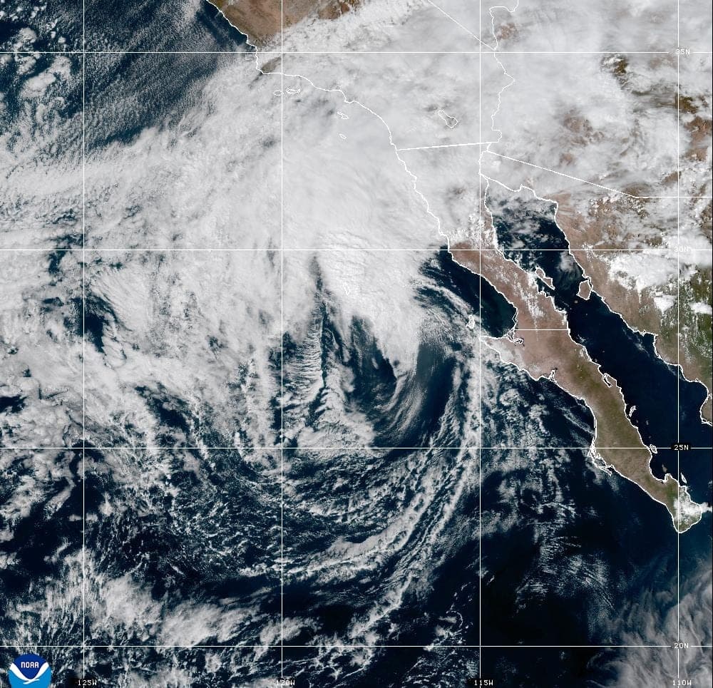
Rachel was a major hurricane last week. By Saturday afternoon it was a weakening tropical storm about 400 miles south of San Diego, racing north-northeast at 30 mph toward northern Baja California, where it is expected to come ashore tonight. The center will pass far south of the Central Coast, so this is not a wind event here. What reaches us is the ocean: big, mixed surf, water levels already running well above the tide tables, and some of Rachel's moisture as showers Sunday night into Monday.
Everything here is as of the National Hurricane Center's advisory 55 (2 PM PDT Saturday, October 10) and the National Weather Service products issued Saturday afternoon. Forecasts change. For the latest, use hurricanes.gov and your local NWS office: Los Angeles/Oxnard covers San Luis Obispo and Santa Barbara counties, and the Bay Area office covers Monterey and Santa Cruz.
The short version
- Rachel lands in Baja, not here. The NHC expects landfall on northern Baja California tonight. Rachel will then be post-tropical by Sunday morning, cross the Southwest on Sunday, and dissipate by Sunday night.
- The surf is the main hazard. A High Surf Advisory covers San Luis Obispo County beaches and the Santa Barbara County Central Coast from 6 AM Sunday to 10 PM Monday, with 8 to 12 foot breakers and dangerous rip currents.
- Tides are running high. Port San Luis peaked at 7.1 feet on Saturday morning, 1.4 feet above the predicted tide. The NWS expects highs near 7.5 feet on Sunday morning and 7 feet on Monday morning, with minor to moderate flooding in low spots like Oceano. Monterey Bay and the Big Sur coast are under a Coastal Flood Advisory too, until 3 PM Tuesday.
- Rain comes late Sunday. Showers are likely Sunday evening through Monday afternoon around San Luis Obispo, Santa Maria and Santa Barbara, but totals are light, generally under a quarter inch.
Where Rachel has been
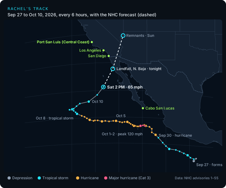
Rachel's center every six hours from the NHC's 55 advisories, colored by strength, with the forecast track dashed.
Rachel formed as a tropical depression off southern Mexico on September 27 and became a tropical storm later that day. It became a hurricane on September 30 and peaked on October 1 at 120 mph (105 knots), with a central pressure of 950 mb. That made it a Category 3 major hurricane, well south of Baja California.
For a week it tracked west across open ocean, slowly weakening over cooler water, and it dropped to a tropical storm on October 8 near 124°W. Then the steering changed. A low to its northwest, in the NHC's words a "mid-level cut-off low", turned Rachel north and then north-northeast, and it has sped up toward the coast since Friday night. On Saturday afternoon strong southwesterly wind shear had blown its storms well northeast of the center. The NHC describes Rachel as "transitioning to a post-tropical storm."
The forecast track
The NHC's 2 PM forecast takes the center to about 30.4°N 116.3°W by 11 PM Saturday, onshore in northern Baja California. By 11 AM Sunday the remnants are near 36.3°N 114.1°W, over the Nevada and Arizona border region, as a post-tropical low with 45 mph winds. The NHC forecasts Rachel to dissipate by Sunday night.
A Tropical Storm Warning covers Baja California's Pacific coast from Punta Eugenia to the U.S. border. A Tropical Storm Watch covers the Southern California coast from the border to the San Diego and Orange County line. There are no tropical storm watches or warnings anywhere on the Central Coast.
What it means for the Central Coast
Surf and rip currents
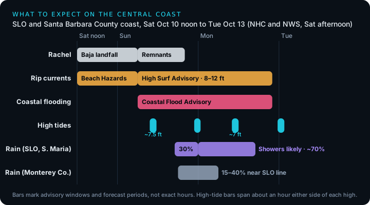
Several swells are stacking up at once. The NWS Los Angeles office describes "a very complex series of swells from the south, west, and northwest": energy from Rachel, a long-period southern hemisphere swell, northwest swell and local wind swell. For San Luis Obispo County beaches and the Santa Barbara County Central Coast, a Beach Hazards Statement runs through late Saturday night. A High Surf Advisory then follows from 6 AM Sunday to 10 PM Monday, with 8 to 12 foot breaking waves. Farther north, the Bay Area office expects a long-period west swell from a gale in the central North Pacific on Sunday, on top of Rachel's southerly swell. Its Beach Hazards Statement for Monterey Bay and the Big Sur coast runs through Monday evening, with breaking waves up to 16 feet and sneaker waves.
The forecasters' advice: stay out of the water, or stay near an occupied lifeguard tower; stay off rocks and jetties; and never turn your back on the ocean. Mixed swells also bring sneaker waves, which can run much farther up the beach than the waves before them.
Surfing an advisory-size mix of south and west swell is not a beginner day anywhere. South-facing spots will take the most of Rachel's energy. Check the buoys on the Conditions Console before you paddle out, and see our Central Coast surfing guide for how each break handles a south swell.
Boating and kayaking the NWS expects Small Craft Advisory winds in the inner waters north of Point Sal, mainly in the afternoons and evenings, through Tuesday. The outer waters get steep seas of 10 feet or more from Saturday afternoon into at least early Monday, with a 30% chance of gale-force winds early Sunday morning. The forecasters also warn that swells from the west and south "can create a confused sea state".
Coastal flooding and high tides
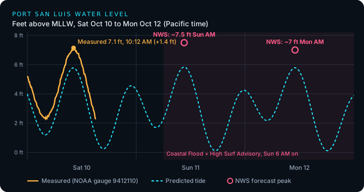
Measured water level at NOAA's Port San Luis gauge (9412110) against the predicted tide. Predictions cover the astronomical tide only, so the gap between the lines is extra water the tables don't include. Low pressure, wind and waves all add to it.
Water levels have been running well above the tide tables all along the coast. At Port San Luis on Saturday the gauge ran 1.1 to 1.4 feet above the prediction from midnight through the afternoon. It peaked at 7.1 feet above MLLW at 10:12 AM, against a predicted high of 5.8 feet. The NHC says water levels in some areas are running "as much as 1.5 feet above predictions". This year's El Niño has also been lifting sea level along the coast, which we covered in El Niño 2026. The forecasts don't say how much of this weekend's gap comes from it.
A Coastal Flood Advisory covers San Luis Obispo County beaches and the Santa Barbara County Central Coast from 6 AM Sunday to 10 PM Monday. The NWS expects high tides to peak around 7.5 feet on Sunday morning (predicted high 10:35 AM) and around 7 feet on Monday morning (11:02 AM). It expects "minor to moderate flooding of sea water" around high tide at beaches and harbors, with low-lying areas "most susceptible, including Oceano." It also expects increased beach erosion and "large secondary high tides" each evening. The NWS rates the risk of significant damage here as very low. The serious flooding is to the south: a Coastal Flood Warning is up for Los Angeles County beaches, where the NWS warns of damaging flooding at the Sunday morning high tide. For Southern California and northern Baja as a whole, the NHC expects "moderate to major coastal flooding".
Monterey Bay and Big Sur the Bay Area office has a Coastal Flood Advisory until 3 PM Tuesday for Northern and Southern Monterey Bay and the Big Sur coast. It warns of up to 1.4 feet of water above ground in low-lying areas near shorelines and tidal waterways, flooded coastal trails, and some low-lying beaches cut off at high tide. Its benchmark San Francisco gauge is forecast at 7.3 feet MLLW at 12:18 PM Sunday, 1.4 feet above normal. High tide along the coast can come up to about 90 minutes earlier or later than in San Francisco.
Tidepooling the predicted lows look good on paper (0.1 ft at 5:29 PM Sunday and 6:11 PM Monday). With the water running more than a foot high and 8 to 12 foot surf, though, the reefs won't drain the way the tables say, and waves will sweep the outer rocks. Skip the exposed reefs until the advisory ends and the surf drops.
Fishing stay off jetties, breakwaters and the outer rocks while the advisory is up. Piers are the safer option, but watch for spray and closures.
When to expect rain
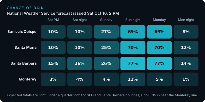
Rachel's moisture arrives in two steps. An upper-level low southwest of Los Angeles draws Rachel's moisture north tonight and Sunday, mostly into Los Angeles and Ventura counties, south and east of Point Conception. A second upper low then drops down through California and turns the rain into a showery pattern from Sunday evening through Monday. That second step is the Central Coast's best chance of rain.
- Saturday night into Sunday afternoon mostly dry north of Point Conception, with a 10 to 30% chance of rain. Santa Barbara has a slightly better chance of a little rain Saturday night and Sunday morning.
- Sunday evening and night showers become likely, about a 70% chance in San Luis Obispo and Santa Maria and 77% in Santa Barbara. San Luis Obispo could see a tenth to a quarter of an inch.
- Monday showers are likely until about 5 PM, then clearing. Monday's totals are under a tenth of an inch.
- Monterey County mostly dry. The Bay Area office gives a 15 to 40% chance of showers in the Santa Lucia Range and near the San Luis Obispo County line late Sunday into Monday morning, with amounts of 0 to 0.05 inch.
The NWS expects totals from Saturday through Tuesday to be generally under 0.25 inch for San Luis Obispo and Santa Barbara counties. The heavier rain stays in Los Angeles County, the San Gabriel Mountains and the desert Southwest, where the NHC warns of flash and urban flooding with 1 to 3 inches of rain and up to 5 inches in places. The NWS also gives a 5 to 10% chance of thunderstorms through Monday, mostly south of Point Conception. The Los Angeles office stresses that any change in Rachel's track could change the rain forecast, so check again on Sunday.
After Rachel
Sunday and Monday turn cool: the Bay Area office expects highs 5 to 15 degrees below normal, and the Los Angeles office calls it relief after a long stretch of very hot weather. Rain ends by Tuesday. The coastal flood and beach advisories begin to lift Monday night through Tuesday afternoon, with some Bay Area shoreline advisories running into Wednesday. The NWS then expects a fast turnaround: high pressure builds from Wednesday, and offshore flow brings rapid warming and drying into next weekend, and the Los Angeles office says "a weak to at least locally moderate Santa Ana Wind event is likely" in Southern California.
How to follow it
- The storm NHC's Rachel page. After Saturday afternoon's advisory, the NHC scheduled an intermediate advisory at 5 PM PDT and a full advisory at 8 PM PDT.
- Local hazards NWS Los Angeles/Oxnard for San Luis Obispo and Santa Barbara counties, and the NWS Bay Area for Monterey and Santa Cruz.
- Live water levels and surf the Port San Luis Conditions Console shows the gauge against its prediction (the residual) and the nearby buoys. Tide Intelligence has the week's highs and lows.
Keep reading
Surfing · Fishing · Tidepooling · Wildlife · Avila · Morro Bay · California coast · 9 min
El Niño 2026: Where It Stands and What It Means for the California Coast
A very strong, possibly record El Niño is building into winter. Where the forecasts stand in October 2026, what's already showing up off the Central Coast (warm water, higher tides, southern fish), and how to plan surf, fishing and tidepool days around a stormy season.
Surfing · Fishing · Tidepooling · Avila · Morro Bay · California coast · 22 min
The Kelvin Wave Reaching California: What the Tide Gauges Show
Updated October 13: the 2026 El Niño's Kelvin wave reached California in late September, and NOAA gauges from La Jolla to San Francisco ran 6 to 12 inches above last year before Tropical Storm Rachel piled on more. What the wave is, what the gauges show, and what it means for Central Coast king tides this winter.
Surfing · Morro Bay · Avila · California coast · 5 min
Do Mexican Hurricanes Send Swell to the Central Coast?
Most East Pacific hurricanes never send us a wave: Baja is in the way. How hurricane swell reaches California when it does, how long it takes, what 12 years of buoy data show, and how to read our new storm tracker.